Peningagjá: The Real History of Þingvellir's Money Fissure
The fissure is not really called Peningagjá. The coin tradition probably does not begin where the guidebooks say it begins. The wishing well was a signpost put up in the 1920s, not a folk tale. And the bridge everybody stands on was not built for tourists at all — it was built for a king, and then it spent decades being used as a working road, including by a hay truck in the summer of 1947 that had no business being anywhere near Þingvellir.
What You See Today
Most visitors reach Peningagjá about four minutes’ walk from the church at Þingvellir. They stop on the bridge, look down through the water at a scattering of coins on the bottom, take a photograph, and walk on. The fissure gets perhaps ninety seconds of a Golden Circle day.
That is a shame, because almost every detail in the standard account of this place is either incomplete or quietly wrong. What follows is what the documented sources actually say.
Peningagjá Is a Nickname Inside a Nickname
Peningagjá is not a separate fissure. It is a stretch of a larger one, and the naming runs three layers deep.
The parent feature is Flosagjá, one of the major water-filled rifts at Þingvellir, named after Flosi Þórðarson of Svínafell — the chieftain who led the burning of Njáll and his sons in Njáls saga. Opposite the assembly site the fissure splits along a long stretch, and the eastern branch of that split is Nikulásargjá. Between the two branches lies Spöngin, the narrow tongue of lava that eighteenth- and nineteenth-century antiquarians believed had held the original Lögberg.
Peningagjá — money fissure — is the name attached to the section of Nikulásargjá directly beneath the bridge. Many visitors, and a fair number of guides, know the place only by that nickname and have no idea it has a proper name at all.
It also gets confused with Silfra, constantly, including in tour listings. They are different fissures with different rules. Silfra lies further east, largely submerged in Þingvallavatn, reaching around 60 metres deep, and it is the site permitted for diving and snorkelling. Peningagjá is crossed by a road bridge, is looked at from above, and is not a swimming site. They share a water source and a geological origin. They are not interchangeable.
The Man the Fissure Is Named For
The fissure carries the name of Nikulás Magnússon, district magistrate of Rangárvallasýsla, born around 1700, who died at Þingvellir on 24 July 1742 during the annual assembly.
Most English-language pages compress this into a single clause — named after a magistrate who drowned here in 1742 — and move on. The Icelandic sources are a good deal more specific, and a good deal less settled.
The closest thing to a first-hand record comes from Sveinn Sölvason, who was sitting at the Alþingi that summer for the first time as deputy lawman for the north and west, and who later compiled Íslands árbók, an annal covering 1740 to 1781. His account describes the magistrate leaving his bed one night and wading east across the river Öxará. A boy went with him — old enough to follow, not old enough to stop him — and tried to keep watch, but was sent away. The boy ran back to Þingvellir in fear to raise help. By the time men came, the magistrate had vanished.
That is a materially different story from “a magistrate drowned in this fissure”. It is a night, a river crossing, a witness who was dismissed, and a search that came too late.
The folk-tale version, collected in Íslenzkar þjóðsögur og æfintýri, says he threw himself in because he feared he would lose a case then pending against his reputation. Whether that was the reason or a story built afterwards to explain the death, it is the explanation that survived orally, and it is why the place-name stuck rather than fading.
Nobody Actually Knows Which Fissure He Died In
This is the detail that almost never surfaces in English.
Some sources place the death in Nikulásargjá itself, which would be circular but consistent. Others place it in Flosagjá, the parent fissure. Espólín records that he made away with himself in Vatnsgjá and was found there dead — a different name again. And Nikulásargjá is itself recorded under an older variant, Nikulásarpyttur, Nikulás’s pit.
The honest position is that the fissure is named for Nikulás Magnússon, but the precise stretch of water in which he died is not established by the sources. Anyone standing on that bridge is standing at a memorial whose exact location is uncertain. That is a more interesting thing to be told than a false certainty.
1907 — The Bridge Was Built for a King
The bridge across Nikulásargjá was laid in 1907, and it was not built for tourism. It was built because a king was coming.
Frederik VIII of Denmark visited Iceland in the summer of 1907 with a party of around two hundred, including Danish parliamentarians and foreign journalists. In preparation the state built a carriage road from Reykjavík to Þingvellir and onward east to Geysir, Gullfoss and Þjórsártún. It became known as Konungsvegur, the King’s Road.
The scale of it is easy to underestimate. The road cost the Icelandic treasury the equivalent of fourteen percent of a full year’s state expenditure. It was built up in sections with culverts, bridges and well-made cairns. The king’s party reached Þingvellir on the evening of 1 August after eight hours of travel, and the crowd lining Almannagjá called out for him as he rode down. Having built a carriage road at considerable expense, the state then watched the king decline the carriage. He preferred to ride.
The bridge over Nikulásargjá was part of that road. And the road did not go to Þingvellir. It went through Þingvellir, to Bruarfoss Waterfall and onward east, into the farming districts – and Geyser and Gullfoss waterfall area. That is the detail everything else in this article hangs on.
The King's Road Is Still Under the Asphalt
During resurfacing work on the approach west of the bridge, the asphalt was stripped back carefully — because at Þingvellir you can turn up archaeology anywhere — and stone edging appeared almost at once. First on the north side of the road, then more clearly on the south. Those are the built kerbs of the original Konungsvegur, still in place beneath the modern surface.
The modern road and the 1907 King’s Road are the same road. Nothing was abandoned and rebuilt elsewhere. The route persisted, and so did its use.
How the Coin Tradition Really Started
The standard story is that once the bridge was built, visitors began throwing small coins into the water below, and the stretch gradually acquired the nickname Peningagjá. That much is well supported, including by Þingvellir National Park’s own place-name register.
But there are two complications that are almost entirely absent from English-language coverage.
The first is older. The park’s place-name records trace the name to two possible events, not one. The second is an eighteenth-century case tried at Þingvellir concerning counterfeit currency — coins adulterated with a cheaper metal. According to the sources the offending coins were cut apart and scattered into the fissures at Þingvellir as part of the disposal. Which fissure received them, whether Peningagjá or Silfra or another, is not recorded. But it means the association between this landscape and discarded money may predate the tourist tradition by more than a century.
The second complication is that the wishing well is not folklore. It is signage. In the 1920s a sign reading “to the wishing well” was put up directing visitors to Peningagjá, and the story that you could make a wish there spread from that point. Þingvellir National Park states plainly that there is no folk tale attached to Peningagjá — that the coins in the freezing water are better read as a symbol of what the water itself is worth.
This is worth saying clearly, because a great deal of published travel writing presents the wishing tradition as ancient Icelandic custom. It is roughly a century old, and it started with a signpost written in English.
As for the claim that Frederik VIII threw the first coin from the new bridge: accounts say so, and it is repeated as established fact across a large number of travel sites. The park’s own wording attributes it to accounts rather than to record. Treat it as tradition.
Why You Should Not Throw Coins Now
This has changed, and a lot of published guidance has not caught up.
Coins are metal. Metal sitting in still, cold, extraordinarily pure water does not simply lie there looking picturesque. It corrodes, and heavy metals from decades of accumulated coins have been measured entering the water system at levels beyond what is acceptable.
Rangers have spent years clearing coins not only from Peningagjá but from Flosagjá, from the river Öxará, and — most uncomfortably — from Drekkingarhylur, the Drowning Pool, where women condemned under the moral statutes were executed by drowning between 1590 and 1749. Rangers have pointed out the obvious wrongness of treating an execution site as a wishing well. Drekkingarhylur is also deep, and hazardous to dive, which makes clearing it genuinely difficult. Coins recovered by rangers have historically been collected and given to charity rather than thrown away.
The practical position today is simple. Throwing coins into the fissures at Þingvellir is not something to do. Look at the ones already down there, understand what they cost the water, and keep your change.
Water That Fell as Snow Before You Were Born
The water in Peningagjá is not run-off and it is not river water. It begins as meltwater from Langjökull, roughly 50 kilometres to the north, and travels underground through porous post-glacial lava before surfacing in the fissure system at Þingvellir.
The park’s own figure for Silfra is around thirty years underground. The wider range cited in the literature is thirty to a hundred years. Either way, water surfacing in these fissures today fell as snow on the glacier before most of the people photographing it were born.
That journey is what produces the clarity. Decades of filtration through lava strip the water of suspended particles, giving visibility that in the adjacent fissures routinely exceeds 80 to 100 metres. The temperature holds at roughly 2 to 4 degrees all year, which is why the fissure neither freezes over in winter nor warms in summer.
Most of the water that forms Þingvallavatn arrives this way, from beneath the lava rather than across it. There is an old Icelandic saying for it: fertile is the water that runs under lava.
Two Plates, and a Number That Gets Misused
Þingvellir sits on the Mid-Atlantic Ridge, where the North American and Eurasian plates pull apart, in one of very few places on earth where that boundary is visible on land rather than hidden under ocean.
The figure everybody quotes is about 2 centimetres a year. That figure is correct for full plate motion. It is not the rate at which Þingvellir itself is pulling apart, and it is emphatically not the rate at which any individual fissure widens.
Spreading in south Iceland is split between two parallel rift segments, the Western Volcanic Zone — which runs through Þingvellir — and the Eastern Volcanic Zone. Þingvellir does not get the whole 2 centimetres. GPS measurement across the Þingvellir graben has produced a spreading rate of roughly 6.7 millimetres a year. The graben is also subsiding rather than only widening: levelling profiles show continuous downward movement, and since the lava flowed the valley floor has dropped around 40 metres while the rifting has amounted to about 70. Þingvellir National Park’s own estimate for how fast individual fissures widen is one to five millimetres a year.
So the honest answer to how fast Peningagjá is getting wider is: slowly, at a rate measured in single millimetres, but continuously — and the movement is downward as well as outward.
It does not always move gently. In the summer of 2000 two severe earthquakes struck south Iceland with epicentres 40 to 50 kilometres from Þingvellir. Stones fell from the ravine walls. Water surged up out of the rifts. And the water in Flosagjá, normally glass-clear, was thrown into such turbidity that the coins on the bottom could not be seen.
The rift is not a museum exhibit. It is load-bearing geology that periodically releases.
Why Was There a Hay Truck at Peningagjá?
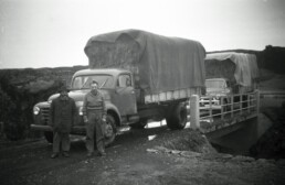
I have a photograph, taken in 1947, of a loaded hay truck at Peningagjá. My father is driving the first car and is taking the photo.
The interesting question about that photograph is not what a truck is doing on the bridge. It is what hay is doing on the truck.
Icelandic farmers cut hay on their own land. That is what the home field was for. Hay was not hauled between districts, let alone between one end of the country and the other, because there was no reason to do it and no cheap way to do it. A truckload of hay crossing Þingvellir is not a picture of ordinary farm work. It is a picture of something having gone badly wrong.
What had gone wrong was the summer of 1947.
The weather record for that year is unambiguous. Through July the rain fell almost without pause across the south and west of Iceland, while the northeast and east had good haymaking weather. August repeated it — more rain in the south and west, very favourable conditions in the northeast. That is most of the haymaking season, and the south simply could not get a crop dry.
It was not the only thing pressing on the land that year. On 29 March 1947 Hekla erupted after more than a century of quiet, throwing a plume some 30 kilometres into the air, and it went on erupting for thirteen months, with heavy lava flow and repeated tephra fall over the farming districts of the south.
So farms across the south of Iceland went towards winter without enough hay to feed their animals, and hay had to be brought down from the north, where the summer had been kind.
Which brings in the third thing about 1947. Iceland’s foreign currency reserves had run out that year, and the country was deep into what Icelanders call the skömmtunarár, the rationing years — import restrictions and ration coupons on a long list of goods, at their most severe between 1947 and 1949. Fuel was not something you simply bought as much of as you liked. Marshall aid did not begin arriving until 1948, and the rationing eased only gradually after that.
Put those three things together and the photograph stops being a snapshot and becomes a document. A wet summer, an erupting volcano, and fuel under rationing — and trucks nonetheless driving the length of the country with hay on the back, over a bridge built forty years earlier for a Danish king, because the alternative was livestock starving.
Where That Load Was Going
The hay on that truck was going to the farm at Skálholt, in Biskupstungur.
My father drove the trip in his own truck. Also in the photograph is Húnbogi Hafliðason from Hjálmsstaðir in Laugardalur — the valley the road runs through between Þingvellir and Biskupstungur — presumably at the wheel of the second truck.
Húnbogi is worth a paragraph of his own. He was born on 27 November 1891, and Hjálmsstaðir was known across the district for verse; the household turned out so many rhymers that people spoke of the Hjálmsstaðir academy. He was a reciter of rímur, and said of himself that he had been born down into the age of them. He was also the kind of man who could turn his hand to anything.
In November 1966, a few weeks before his seventy-fifth birthday, Vísir sent a reporter to interview him. They found him at the Coca-Cola bottling plant in Reykjavík, where he worked from eight in the morning until six at night handling crates of twenty-four bottles — thirty-six cases to a lift, a lift roughly every five minutes, at seventy-four years old. The paper described him as the industry of the whole nation compressed into one man. Asked what the greatest gift in life was, he said: courage.
Nineteen years before that interview, he was on the road over Þingvellir with a load of northern hay.
This is why the photograph matters more than anything else on this page. Peningagjá is presented to visitors as a curiosity — a pretty crack in the rock with coins at the bottom and a wishing-well story attached to it. In the summer of 1947 it was a bridge on the only sensible route east, being crossed by men hauling emergency winter feed the length of Iceland during a rationing year.
The coins in the water and the hay on the truck belong to the same bridge, forty years apart.
Visiting Peningagjá
It is one of the easiest features in the park to reach — a short walk from Þingvallakirkja and the farmhouse, on the road past Spöngin. Nikulásargjá is the proper name; Peningagjá is the nickname for the stretch under the bridge. Do not throw coins. There is no swimming or diving here; that is Silfra, and it requires a permitted operator.
The clarity of the water reads best when the sun is not directly on the surface. Overcast conditions, or low angled light, will usually give you the bottom rather than a reflection of the sky.
And take the extra ten minutes to walk out onto Spöngin, between the two branches. Most visitors photograph the coins and turn back without realising they are standing beside what earlier generations believed was the original Lögberg.
Common Questions
What does Peningagjá mean? It translates as money fissure or money gorge — peningur meaning money or coin, gjá meaning fissure or rift. It is a nickname. The proper place-name is Nikulásargjá.
Why is it called Nikulásargjá? After Nikulás Magnússon, district magistrate of Rangárvallasýsla, who died at Þingvellir during the assembly on 24 July 1742. Contemporary accounts describe him leaving his bed at night, crossing the Öxará, and disappearing. The exact fissure in which he was found is recorded inconsistently across the sources.
When was the bridge over Peningagjá built? In 1907, as part of Konungsvegur, the King’s Road, built for the visit of King Frederik VIII of Denmark. The coin-throwing tradition dates from after the bridge was in place.
Can you still throw coins into Peningagjá? No. Coin-throwing is no longer permitted, and heavy metals from decades of accumulated coins have affected water quality. Rangers have been removing coins from Peningagjá and from other fissures at Þingvellir.
How deep is it? The Flosagjá system reaches depths of around 25 metres in places. The clarity of the water makes it look far shallower than it is, which is a common source of misjudgement in photographs.
Where does the water come from? Meltwater from Langjökull, around 50 kilometres north, which travels underground through porous lava for an estimated thirty to a hundred years before surfacing in the fissures at Þingvellir. That filtration is what produces the clarity, and it holds the water at roughly 2 to 4 degrees all year.
Is Peningagjá the same as Silfra? No. Silfra is a separate, deeper fissure to the east, largely submerged in Þingvallavatn, and it is the permitted diving and snorkelling site. Peningagjá is viewed from the bridge above.
Sources
Þjóðgarðurinn á Þingvöllum, örnefnaskrá — entries for Peningagjá and Nikulásargjá.
Þjóðgarðurinn á Þingvöllum — Þinghelgin; Tectonic Movements; Silfra.
Sveinn Sölvason, Íslands árbók, annal covering 1740–1781.
Jón Espólín, Íslands Árbækur í sögu-formi.
Íslenzkar þjóðsögur og æfintýri, Viðburðasögur — “Nikulásargjá”.
“Heilir hildar til — heilir hildi frá”, interview with Húnbogi Hafliðason, Vísir, 7 November 1966, p. 7.
Veðurstofa Íslands, monthly weather summaries for 1947.
Sigurður Þórarinsson, “The eruption of Mt. Hekla 1947–1948”, Bulletin Volcanologique 10, 1950.
Islam, M. et al., “Continuous subsidence in the Thingvellir rift graben, Iceland”, Journal of Geophysical Research: Solid Earth, 2016.
LaFemina, P. et al., on partitioned spreading rates across the Western and Eastern Volcanic Zones, 2005.
Contemporary press coverage of the 1907 royal visit and the building of Konungsvegur.