This story is part of The Untold Stories of the Golden Circle — a local’s living archive of the district.
Most people see Brúarfoss — often written Bruarfoss — before they hear the name. It is one of the images Iceland travels on: pale blue water folding into a narrow rift in dark rock, photographed from a small wooden footbridge between Laugarvatn and Geysir.
Almost nobody standing on that footbridge knows they are standing at a road.
For something close to a thousand years this was a crossing — the place where you got over Brúará and into the district beyond. It is the reason the river has the name it has, the reason the waterfall has the name it has, the reason a famine in 1602 turned violent here, and the reason a Danish king and two parliaments came through in 1907. The waterfall itself was incidental to all of it. Nobody came to look at the water. They came because this was the way across.
Then in 1961 the crossing moved four to five kilometres downstream, and Brúarfoss went quiet for fifty years — until photographs found it, and nobody who came knew it had ever been anything but a view.
Why You Could Not Simply Wade
Start with the question most people actually arrive with, because the answer is also the reason any of this happened.
Brúará is not a glacial river. It is spring-fed, rising out of the ground at Rótarsandur, and the water reaching Brúarfoss has never been near Langjökull — a detail most descriptions get wrong.
That is the whole explanation for the colour. A glacial river carries suspended rock flour and runs opaque grey-green. Brúará runs clear, and what you are looking at is clean water over dark volcanic rock, with the depth of the rift concentrating the blue. It is the opposite process from glacial milk, which is why Brúará looks like this while Hvítá, a short distance east, does not.
The geologist Guðmundur Kjartansson, who studied this stretch of river closely in the 1940s, called Brúará one of the most pronounced spring rivers of its size in the whole country. It never rises violently, and it does not freeze until well below Brúarfoss. Its flow, he wrote, is exceptionally steady whatever the weather does.
Which is also why there had to be a crossing. A glacial river swells with summer melt and falls away in autumn; sooner or later you can wade it. Brúará does not oblige. A river like that either stops you or gets bridged.
At the falls it was bridged, by the river itself. A natural stone arch spanned the water where it narrows into the rift.
The Name Is the Evidence
The older form of the name is Brúarárfoss — the waterfall of Brúará. And Brúará means bridge-river.
Read that in order and it tells you the whole history. The crossing came first. The river was named after the crossing. The waterfall was named after the river.
So the most famous natural feature on this stretch of water is named, at one remove, after a piece of infrastructure. English descriptions usually collapse this into a single step and end up muddling what was named after what. The extra syllable in the older form is the giveaway.
Whose Crossing It Was
Biskupstungur is the tongue of land between Brúará on the west and Tungufljót on the east. The district is defined by its water — which means a crossing on Brúará is not a convenience. It is the door.
Landnámabók records that Ketilbjörn the Old came from Naumudalur in Norway in a ship called Elliði, landed at the river mouth in Reykjavík that still carries the ship’s name, and rode inland looking for land. He claimed all of Grímsnes up from Höskuldslækur, all of Laugardalur and the whole of Biskupstunga up to Stakksá, and settled at Mosfell. His son was Teitur, his grandson Gissur the White, and his great-grandson Ísleifur — the first bishop of Iceland, at Skálholt, downstream on this same river.
So from very early on, the crossing at Brúarfoss belonged to whoever held the land beyond it. For most of the following centuries, that was Skálholt.
1602: The Crossing Is Broken on Purpose
You only bother to destroy a bridge that people are using.
The oldest written account comes from Jón Halldórsson of Hítardalur, in his Biskupasögur. In the hard years around 1602, he says, destitute and displaced people were coming to Skálholt from every direction in great numbers. The steward of the estate judged that the pressure would ease if the natural stone arch on Brúará — the one the river was named for — were broken. He had it done with a work crew, with the knowledge, if not the counsel, of the bishop’s wife Helga Jónsdóttir, but without the knowledge of Bishop Oddur, who took it very badly when he learned of it. The steward drowned in Brúará shortly afterwards.
Jón Halldórsson was born in 1665 and came to school at Skálholt in 1679, roughly seventy-seven years after the events he describes. Close enough that the account is unlikely to be invented, far enough that the detail cannot be leaned on too hard.
Three things the usual account gets wrong
The direction of travel. The story is usually told as starving peasants being blocked from reaching fertile church land. The oldest source says the opposite. People were flocking to Skálholt, and the point was to reduce the number arriving at the door.
Who did it. Not the Church as an institution, and not on the bishop’s orders. A household official acting on his own judgement, against the wishes of a bishop who found out afterwards.
Which church. Skálholt is often described in English in terms that read as Catholic. By 1602 the Reformation was half a century old and Skálholt was a Lutheran seat.
And the arch is still there
This is the part that is missing from every English account, and it is not a legend.
There is a stone arch across Brúará at the falls today. Few people notice it, because it lies under the water. Guðmundur Kjartansson, who published a study of it in Náttúrufæðingurinn in 1948, had been to the spot seven or eight times and could always make it out through the white water breaking over it. Between the waves, he reckoned, it is barely knee-deep. In very low water the river is said to run entirely under the arch except for the surf, and it has been claimed that a man once took his chance and ran across the river on it.
I first heard this from Óskar at Brekka, whose farm sits on the old road to this crossing. He told it as it is told in the district: that Skálholt’s men did not destroy the arch at all, but broke enough off the top of it to put the crossing out of use — and that what is left is still down there.
Guðmundur considered exactly that explanation and did not accept it. His view was that the arch now in the river is unbroken, sits too low to have ever served as a crossing, and that taking the top off it would have been work too difficult and too dangerous for 1602 tools. He thought the original stood a little upstream, where the fissure narrows to about a metre across and only thirty centimetres at water level.
So the district and the geologist disagree, and both accounts are careful ones. What neither disputes is that a natural stone bridge crossed this river here, that it was deliberately put out of use in a famine year, and that something of it is still under the water.
One honest caution on the story itself. Broken stone arches recur as a motif in Icelandic folklore — Brúarhlöð on Hvítá carries essentially the same tale, and there are others. The named individuals and the estate setting give the Brúará account more weight than a wandering story. But it was written down a century after the fact, and it is best read as a well-attested tradition rather than a documented event.
1680: The Farmers Try to Rebuild It
What happened next is the strongest evidence that this was a working road rather than a curiosity.
Around 1680 — some eighty years after the arch was broken — the farmers of Biskupstungur took the matter into their own hands. Biskupasögur names the man who led them: Jón Jónsson smiður í Miklaholti, the smith at Miklaholt, with other leading men of the district. They rolled large boulders down into the narrows of the river to get a bridge across it again, and built the crossing up on top of them.
It did not hold. The winter floods on Brúará broke the work apart, and the repairs had to be done again and again.
People do not haul boulders into a river repeatedly, across generations, for a scenic spot. They do it for a road.
And some of that work is still in the river. Wedged between the walls of the fissure at its narrowest point, about thirty centimetres below the surface, sits a single large stone — a few hundred kilos, of the same grey basalt as the gorge walls, and somewhat water-worn. In July 1941 the water was so low that the stone stood clear of it, and Guðmundur was able to climb down onto it in the gorge and up the other side, crossing the river that way. By October 1946 there was more water and it was submerged, but still plainly visible.
He worked through four explanations for how a stone that size came to be there and settled on the last one: that it is the final remnant of the bridge the men of Biskupstungur built around 1680.
1907: The Last Time It Was a Road
In 1907 Frederik VIII of Denmark came to Iceland with a retinue of around two hundred, including a large party of Danish parliamentarians, and the Icelandic state built him a road.
It ran from Reykjavík over Mosfellsheiði to Þingvellir, east through Laugardalur, across Brúará, and up into Haukadalur to Geysir and Gullfoss. It was dug and cleared by hand with shovels, picks and horse-carts, and it has been called Kóngsvegurinn — the King’s Road — ever since. The same journey left another bridge that people still stand on today, at Peningagjá in Þingvellir.
It crossed Brúará here, on a wooden bridge built for the occasion and set just below Brúarfoss.
What the road actually cost
The Icelandic national accounts for 1906 and 1907 were passed together. Road improvement costs across those two years came to 220,257 krónur, of which the King’s Road was the largest part, against total treasury expenditure of a little over 3.1 million — roughly fourteen percent of what the state spent in a year. Measured against the public purse it is probably the most expensive road ever built in Iceland.
The same figure is often repeated as a share of national output, with a modern equivalent of hundreds of billions of krónur attached. That is a different measure and it inflates the claim by an order of magnitude.
A light carriage was brought along for the king, with a driver named Guðmundur Hávarðarson, on the assumption that a monarch would not ride. He turned out to be a capable horseman and rode the whole way. The carriage travelled the entire route empty.
Who built it
The clearing of the road was supervised by Guðjón Helgason, road foreman and farmer at Laxnes in Mosfellssveit, who held charge of the Þingvallavegur and other roads from the year he moved to that farm until his death in 1919. His son was three years old when the family arrived there. He later took the farm’s name as his own and won the Nobel Prize in Literature as Halldór Laxness.
Further east the work was done by local men, and it is close enough to living memory that I have known some of their families. I spent a summer working at the farm at Múli as a boy, and the farmer there had a father who worked on building this road. So did a neighbour of ours near Strokkur. This is a small district, and that road went through the middle of it.
What the road was for
There is a case that it bought Iceland more than a fortnight of ceremony. Ólafur Örn Haraldsson, former warden of Þingvellir National Park and former president of Ferðafélag Íslands, has argued that the preparation for the visit, the journey itself and the relationships formed on it laid the foundation of trust that led to Icelandic sovereignty in 1918.
It was not a straight line — a draft union treaty was produced in 1908 and rejected by Icelandic voters the same year — and 1918 brought fullveldi, sovereignty within a shared monarchy, rather than the full independence that came with the republic in 1944. But two parliaments spent a fortnight together on horseback, and the road they rode crossed the river at this waterfall.
A man who drove a car over it
We know what that 1907 bridge was like because someone drove across it and wrote it down. In Lesbók Morgunblaðsins in 1963, Egill Hallgrímsson described crossing it in August 1927 on what he believed to be the first motor journey to Geysir. The track met the bridge at an angle, so the party had to lift the car bodily to line it up. The bridge ends rested on bedrock on both banks and it stood high above a roaring torrent. The timber was old and had never been meant for cars. One man drove it over alone while the others walked.
By 1948 that bridge was worn out and closed to motor traffic altogether.
A photograph taken from the bridge
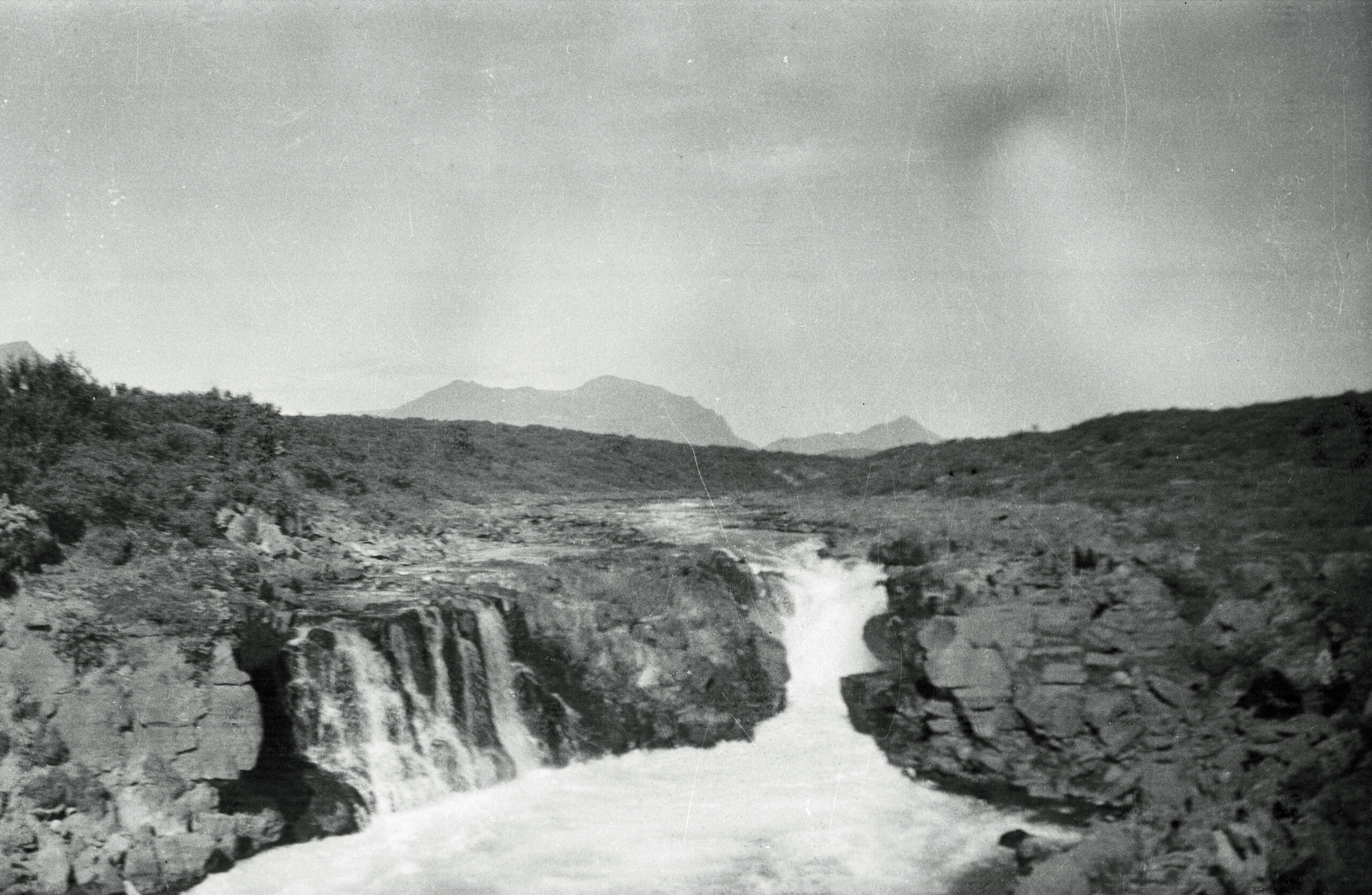
Brúarfoss, around 1950, photographed by my father. Family archive.
My father photographed Brúarfoss around 1950, and for three-quarters of a century the picture sat in the family archive as nothing more than an old view of the falls. Then, in putting this archive together, I looked at where he was standing.
There is no foreground in the frame. The bottom edge of the photograph is white water — no bank, no grass, no rock a man could stand on. The camera sits a few metres above the river and almost exactly over the middle of the channel: both banks fall away symmetrically from the corners of the picture, which is not a view you can get from either shore. Whoever took this photograph was standing on something that spanned the river, a short way below the falls.
In 1950 there was exactly one such thing. The King’s Road bridge of 1907 stood just below Brúarfoss, its ends resting on bedrock on both banks. It had been closed to cars since 1948 — but a closed bridge still carries a man with a camera. Unless some structure below the falls has escaped every written account, my father took this picture from its deck, and in doing so recorded, without meaning to, where the bridge stood.
I state that as strong inference rather than settled fact, because that is this page’s rule. The geometry of the frame allows only one standing place I know of, and it can be tested: the sightline in the photograph can be walked out on the bank until the lip of the falls and the skyline align, and bedrock keeps the scars of bridge ends — bolt holes, cut seats — for a century. I intend to do exactly that, and this section will be updated with what the rock says, either way.
If the reading holds, the photograph is a small document of the road’s last years: the falls entirely alone, no path and no visitors, seen from the last working piece of a crossing that had carried people for a thousand years — about a decade before the new bridge downstream retired it for good.
The Road That Died With It
When the 1907 bridge failed, something larger went with it, and Guðmundur named it plainly in 1948.
The old travellers’ route through here was called með hlíðum — along the slopes — and it was the shortest road between Laugardalur and Geysir. With the crossing gone, that road was abandoned. He wrote that in an age of general tourism it would surely have to be renewed before long, and made a proposal for how to bridge the gorge cheaply: it is only about two metres wide at the narrows, with good basalt bedrock on both sides, and Brúará’s steady spring-fed flow means there is no need to fear the floods and ice that make bridge-building expensive on most Icelandic rivers.
Nobody built it. The road never came back.
Brekka and Miðhús, the two farms in Hlíðar where I used to go as a boy to play with Jói and Hallur from school, sit on that road. Óskar and Hildur farmed at Brekka. What is a quiet lane now was the main way between two of the busiest places on the Golden Circle, and it stopped being one because a bridge fell down.
1961: The Crossing Moves
In the autumn of 1961 a new bridge over Brúará was completed and joined to newly laid road, four to five kilometres downstream of the falls.
That bridge is the reason the Golden Circle exists as a drive. Before it you could not simply go from Laugarvatn east through Laugardalur and Biskupstungur to Geysir by car. Afterwards you could.
For Brúarfoss the effect was the end of a thousand-year job. For as long as anyone had travelled through this district, people had passed the falls because that was where you crossed the river. After 1961 the traffic went over the new bridge, and there was no longer any reason to come here at all.
The place went quiet, and stayed quiet for roughly fifty years.
I grew up six or seven kilometres downstream, and in the 1980s we went up to the falls as children. It was the most beautiful place I knew and there was never anybody else there. That is still the Brúarfoss in my head, and it is not the one people photograph now.
How thoroughly it had been forgotten is easiest to show with one detail. Ungmennafélag Biskupstungna, the local youth association, organised a field trip to Brúarfoss — not for visitors, but for the farmers and families who actually lived in Biskupstungur, so they could go and see it and learn what it was. People living a few kilometres away had to be taken to the waterfall on their own river and told about it.
The 2010s: A Destination for the First Time
What eventually brought people back had nothing to do with getting across the river.
Around 2010, as visitors started coming to Iceland in numbers again, photographs of Brúarfoss began appearing online. Slowly at first, and then not slowly at all. Those images did what no road had done since 1961. What makes that remarkable is that there was no easy way in. You parked on Route 37 and you walked. The original path ran across private land and was never made for the numbers that came; it was worn out and littered until it was closed, and the route that replaced it ran around seven kilometres there and back, two or three hours on your feet. People did it anyway, in numbers, purely to look at the water.
In a thousand years of use, nobody had ever walked to Brúarfoss. They walked past it, on the way to somewhere else.
In April 2023 a car park was opened much closer to the falls, with a fee and a walk of about five minutes at the end. There is an irony in that whole sequence which applies to this article as much as to any other: Brúarfoss was damaged by being written about, and every piece that called it a hidden gem helped make sure it stopped being one.
So the waterfall never changed. What changed is what it was for. It spent a thousand years as a piece of the road network and about a decade as a photograph, and the people who arrive now are, without knowing it, queuing to stand in the middle of a road. The quiet place I walked to as a boy has a car park and coaches in it, and none of that has anything to do with why anyone came here for the first thousand years.
The Walk, and the River
This is the part worth reading before you go.
People have drowned in Brúará, including visitors on the walk to the falls. The reasons are unremarkable, which is exactly the problem. The path runs close to the water for long stretches. The ground is often wet and the rock is slippery. The river is fast and cold, and someone who goes in has very little time before the cold takes their strength — and on this path there is usually nobody positioned to help.
None of that is a reason to stay away. It is a reason to treat the thing in front of you as a river before you treat it as a photograph. I grew up beside this water and I have never once been casual about it.
- Stay well back from the edge, particularly where the path narrows above the water.
- Wear boots with grip. This is not a walk for trainers, and in winter it is not a walk without spikes.
- Do not climb down towards the water for a better angle. The photograph everyone comes for is taken from the footbridge and the marked viewpoints.
- Do not enter the river at any point, in any season. The arch under the water is not a crossing and has not been one for four hundred years.
- Keep children close on the stretches beside the water.
Getting there
The falls are reached from Route 37 between Laugarvatn and Geysir. Since April 2023 there has been an official car park close to the falls, with a walk of about five minutes from it. Parking is paid through the Parka app, currently 750 ISK for a car or an SUV and more for larger vehicles. The track in to it is rough in places.
The older and longer trail is still open, and plenty of people still choose it: around two hours there and back, passing two smaller waterfalls, Hlauptungufoss and Miðfoss, on the way up. It is mostly flat but it can be very muddy after rain. Conditions change with the weather, and in winter both the access track and the path can be genuinely icy.
Common Questions
Why is Brúarfoss so blue? Because Brúará is spring-fed rather than glacial. The water runs clear instead of carrying rock flour, and clear water over dark volcanic rock, concentrated in a deep narrow rift, reads as that intense blue. It has nothing to do with Langjökull, despite what many descriptions say.
Is it Brúarfoss or Bruarfoss? Both refer to the same waterfall. Brúarfoss is the Icelandic spelling; Bruarfoss is what most English speakers write, because the accented ú is awkward to type. The older form of the name is Brúarárfoss.
Where does the name come from? From a natural stone arch that once crossed the river at the falls. The river was named after the crossing — Brúará, bridge-river — and the waterfall after the river.
Is the old stone bridge still there? A stone arch does still cross the river at the falls, submerged and easy to miss. Whether it is the famous one is disputed: local tradition holds that Skálholt’s men broke only the top off it in 1602, while the geologist Guðmundur Kjartansson argued the original stood slightly upstream. It is not a crossing and must not be treated as one.
Was the bridge at Brúarfoss built for the Danish king? Not the one you walk on; the footbridge is modern. But the King’s Road bridge of 1907 stood just below the falls, and the King’s Road ran past Brúarfoss. The royal party crossed the river here.
Was Jón Gerreksson drowned at Brúarfoss? The bishop was drowned in Brúará in 1433, and the story is often attached to the waterfall. The tradition places the killing downstream, near Skálholt, rather than at the falls.
How long is the walk? About five minutes each way from the official car park, which opened in April 2023. The older trail takes around two hours there and back and passes Hlauptungufoss and Miðfoss.
Is Brúarfoss safe to visit? On the marked path, with proper footwear, yes. People have drowned in this river, including on the walk, so stay back from the edge, do not climb down to the water, and do not go in.
Is there a fee? Yes. Parking is paid through the Parka app — currently 750 ISK for a car or SUV, more for larger vehicles.
Sources
Guðmundur Kjartansson, “Steinboginn á Brúará”, Náttúrufæðingurinn, 1. tölublað 1948, pp. 42–47. The surviving arch under the water, the stone wedged in the fissure, the spring-fed character of Brúará, the 1680 rebuilding, the road með hlíðum, and the state of the 1907 bridge.
Jón Halldórsson of Hítardalur, Biskupasögur (Sögufélag edition, p. 190). The breaking of the arch in 1602, the steward, Helga Jónsdóttir and Bishop Oddur; and Jón Jónsson smiður í Miklaholti and the rebuilding around 1680.
Landnámabók (Sturlubók), ch. 99, in Íslenzk fornrit I. Ketilbjörn’s claim to the whole of Biskupstunga and the line from Teitur to Bishop Ísleifur.
Egill Hallgrímsson, “Fyrsta bílferð að Geysi”, Lesbók Morgunblaðsins, 1st issue 1963, p. 4. The 1907 bridge as it stood in August 1927.
Icelandic national accounts (landsreikningur) for 1906 and 1907. Road improvement costs of 220,257 krónur against total treasury expenditure of a little over 3.1 million.
Ólafur Örn Haraldsson on the 1907 royal visit and its part in the road to Icelandic sovereignty in 1918.
Óskar at Brekka in Hlíðar, for the account of the arch as it is told in the district. The childhood memory of the falls before the crowds, the Ungmennafélag Biskupstungna field trip, and the families of the men who built the road through this district are local knowledge from the author.
A family photograph of Brúarfoss from around 1950, by the author’s father, taken from a position over the river below the falls. The reading of the camera position, and its identification with the 1907 King’s Road bridge, are the author’s — stated as inference pending verification on the ground.